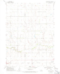
1968 Map of Henderson NE
USGS Topo · Published 1971About this map
Lincoln Creek meanders through the heart of this central Nebraska landscape, defining the topography between the townships of Arborville and Otis. The late 1960s rural layout is characterized by a dense network of groundwater extraction points, marked simply as Well and Wells, which support the agricultural economy of the Valley region. This reliance on irrigation is a hallmark of the era's farming practices in York and Hamilton Counties.
Find a feature on this map
12 named features on this map. Tap any name to fly to it.
Don’t see what you’re looking for? This feature index may not catch every label — zoom into the map to look around manually.
Map Details
Editions of this 1968 Henderson NE Map
This is the sole edition of this map. No revisions or reprints were ever made.
Other maps of this area

1896 · Stromsburg
USGS Topo · 1:125,000

1898 · York
USGS Topo · 1:125,000

1899 · York
USGS Topo · 1:125,000

1955 · Fremont
USGS Topo · 1:250,000

1955 · Lincoln
USGS Topo · 1:250,000

1957 · Fremont
USGS Topo · 1:250,000

1957 · Lincoln
USGS Topo · 1:250,000

1958 · Fremont
USGS Topo · 1:250,000

1958 · Lincoln
USGS Topo · 1:250,000

1962 · Polk
USGS Topo · 1:24,000