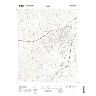
2019 Map of Henderson
USGS Topo · Published 2019About this map
Henderson serves as the central hub of this modern survey, showing the established residential and commercial patterns of Vance County. The city center is flanked by North Henderson and South Henderson, with several prominent burial grounds including Blacknall Cem and Elmwood Cem providing important reference points for local history. To the west, the crossroads at Dabney marks the landscape where Dabney Rd meets the surrounding timber and agricultural tracts. The geography is defined by a dense network of watercourses like Ruin Cr and Nutbush Cr, which flow through the undulating terrain. Outlying areas like Floytan Crossroads and Gill illustrate the persistent importance of rural junctions and small-scale settlements beyond the main city limits, while features like Vance Academy Rd point toward the local educational infrastructure.
Find a feature on this map
208 named features on this map. Tap any name to fly to it.
Don’t see what you’re looking for? This feature index may not catch every label — zoom into the map to look around manually.
Map Details
Editions of this 2019 Henderson Map
This is the sole edition of this map. No revisions or reprints were ever made.
Other maps of this area

1943 · Creedmoor
USGS Topo · 1:62,500

1944 · Creedmoor
USGS Topo · 1:62,500

1953 · Oxford
USGS Topo · 1:62,500

1953 · Greensboro
USGS Topo · 1:250,000

1954 · Greensboro
USGS Topo · 1:250,000

1962 · Greensboro
USGS Topo · 1:250,000

1966 · Greensboro
USGS Topo · 1:250,000

1966 · Oxford
USGS Topo · 1:62,500

1970 · Vicksboro
USGS Topo · 1:24,000
1970 · Middleburg
USGS Topo · 1:24,000