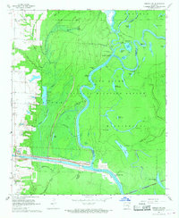
1967 Map of Henrico SW
USGS Topo · Published 1968About this map
White River National Wildlife Refuge dominates this riverine landscape at the junction of Arkansas and Desha counties in the late 1960s. The serpentine path of the White River defines the geography, accompanied by a complex system of backwater lakes and bayous including La Grue Bayou and Wolf Bayou. These waterways represent a vital ecological and transport corridor, evidenced by the infrastructure of Lock and Dam No 1 and Lock No 2 along the southern portion of the sheet.
Find a feature on this map
50 named features on this map. Tap any name to fly to it.
Don’t see what you’re looking for? This feature index may not catch every label — zoom into the map to look around manually.
Map Details
Editions of this 1967 Henrico SW Map
3 editions found
Other maps of this area

1935 · Red Fork
USGS Topo · 1:62,500

1935 · Gillett
USGS Topo · 1:62,500

1939 · Henrico
USGS Topo · 1:62,500

1939 · Big Island
USGS Topo · 1:62,500

1948 · Helena
USGS Topo · 1:250,000

1950 · Helena
USGS Topo · 1:250,000

1953 · Greenwood
USGS Topo · 1:250,000

1954 · Henrico
USGS Topo · 1:62,500

1955 · Helena
USGS Topo · 1:250,000

1956 · Greenwood
USGS Topo · 1:250,000