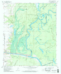
1967 Map of Henrico SW
USGS Topo · Published 1968About this map
The White River and its intricate network of oxbows and backwaters dominate this Delta landscape, illustrating a complex riparian environment in late 1960s Arkansas. Within the White River National Wildlife Refuge, numerous named water bodies like Black Lake, La Grue Lake, and Lower Parish Lake reflect the shifting historical course of the river. Human settlement is sparse and tied directly to the water, evidenced by river access points such as Jacks Bay Landing and Prairie Landing. To the south, the engineering of the Arkansas Post Canal is visible with Lock No 2 and Lock and Dam No 1, representing significant mid-century modifications to the natural drainage. Local heritage is grounded in landmarks like Malcolm Chapel, Gods Missionary Ch, and the Hockenberry Cem, which provide specific points of interest for genealogical research in this riverine terrain.
Find a feature on this map
52 named features on this map. Tap any name to fly to it.
Don’t see what you’re looking for? This feature index may not catch every label — zoom into the map to look around manually.
Map Details
Editions of this 1967 Henrico SW Map
3 editions found
Other maps of this area

1935 · Red Fork
USGS Topo · 1:62,500

1935 · Gillett
USGS Topo · 1:62,500

1939 · Henrico
USGS Topo · 1:62,500

1939 · Big Island
USGS Topo · 1:62,500

1948 · Helena
USGS Topo · 1:250,000

1950 · Helena
USGS Topo · 1:250,000

1953 · Greenwood
USGS Topo · 1:250,000

1954 · Henrico
USGS Topo · 1:62,500

1955 · Helena
USGS Topo · 1:250,000

1956 · Greenwood
USGS Topo · 1:250,000