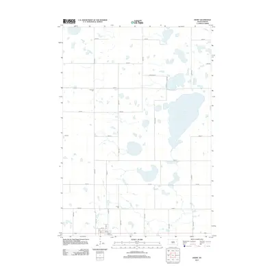
2012 Map of Henry
USGS Topo · Published 2012About this map
The settlement of Henry anchors this portion of Codington County, where the prairie landscape is defined by its numerous glacial depressions and wetlands. To the east and northeast, substantial water bodies like Long Lake and the smaller Stink Lake dominate the terrain, while Blythe Slough sits further south. The map provides significant genealogical value through its marking of local burial grounds, including Graceland Cem in the northwest, Lorinda Cem along the central north-south axis, and Saint Henry Cem located just south of the main town site. The grid of rural roads, including long stretches of 437th Ave and 441st Ave, reveals the organized agricultural layout of the early 21st-century South Dakota plains.
Find a feature on this map
28 named features on this map. Tap any name to fly to it.
Don’t see what you’re looking for? This feature index may not catch every label — zoom into the map to look around manually.
Map Details
Editions of this 2012 Henry Map
This is the sole edition of this map. No revisions or reprints were ever made.
Other maps of this area

1953 · Milbank
USGS Topo · 1:250,000

1953 · Watertown
USGS Topo · 1:250,000

1958 · Milbank
USGS Topo · 1:250,000

1958 · Watertown
USGS Topo · 1:250,000

1973 · Florence
USGS Topo · 1:24,000

1973 · Wallace
USGS Topo · 1:24,000

1973 · Heggs Lake
USGS Topo · 1:24,000

1973 · Garden City
USGS Topo · 1:24,000
1973 · Henry
USGS Topo · 1:24,000
1973 · Kampeska
USGS Topo · 1:24,000