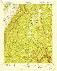
1947 Map of Henson Gap
USGS Topo · Published 1947About this map
Walden Ridge dominates the landscape of this 1947 survey, where the steep Cumberland Escarpment drops sharply into the Sequatchie Valley. This transition zone is marked by isolated settlements and family-named landmarks that reflect a rural mountain economy. The community of Lewis Chapel serves as a central hub on the plateau, featuring the Lewis Chapel Sch and a local post office. Along the valley floor, the Alvin C York Highway follows the path of the Sequatchie River, connecting small religious and social centers like Davis Chapel and Hall Ch. The terrain is deeply incised by numerous waterways such as Cain Creek and North Chickamauga Creek, which carve out distinctive features like The Horseshoe and Redbird Point. These drainages historically dictated the placement of early mountain roads and timber operations, evidenced by labels like Sawmill Creek.
Find a feature on this map
78 named features on this map. Tap any name to fly to it.
Don’t see what you’re looking for? This feature index may not catch every label — zoom into the map to look around manually.
Map Details
Editions of this 1947 Henson Gap Map
This is the sole edition of this map. No revisions or reprints were ever made.
Other maps of this area

1888 · Chattanooga
USGS Topo · 1:125,000

1893 · Chattanooga
USGS Topo · 1:125,000

1935 · Daisy
USGS Topo · 1:24,000

1935 · Soddy
USGS Topo · 1:24,000

1935 · Brayton
USGS Topo · 1:24,000

1935 · Mount Airy
USGS Topo · 1:24,000

1936 · Daus
USGS Topo · 1:24,000

1936 · Henson Gap
USGS Topo · 1:24,000

1936 · Ketner Gap
USGS Topo · 1:24,000

1936 · Fairmount
USGS Topo · 1:24,000