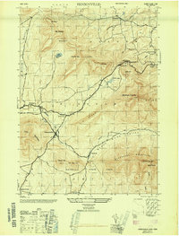
1946 Map of Hensonville
USGS Topo · Published 1946About this map
Hensonville and Windham serve as the primary hubs in this mid-1940s survey of the northern Catskill high country. The landscape is defined by the steep transition from the Batavia Kill valley floor to the peaks of the Blackhead Mountains, including Windham High Pk and Black Dome. This era shows a mix of agricultural valleys and the growing infrastructure of mountain tourism, exemplified by the Mohican Trail and the Observation Tower at Point Lookout. Smaller hamlets like Cornwallville and Maplecrest anchor the rural crossroads, while family-named landmarks like Van Loan Hill and Jennie Notch provide valuable data points for local genealogists. To the south, the boundary of Catskill State Park marks the transition into more densely forested terrain near Thomas Cole Mtn.
Find a feature on this map
42 named features on this map. Tap any name to fly to it.
Don’t see what you’re looking for? This feature index may not catch every label — zoom into the map to look around manually.
Map Details
Editions of this 1946 Hensonville Map
2 editions found
Other maps of this area

1892 · Kaaterskill
USGS Topo · 1:62,500

1893 · Kaaterskill
USGS Topo · 1:62,500

1893 · Durham
USGS Topo · 1:62,500

1894 · Kaaterskill
USGS Topo · 1:62,500

1894 · Durham
USGS Topo · 1:62,500

1899 · Kaaterskill
USGS Topo · 1:62,500

1900 · Phoenicia
USGS Topo · 1:62,500

1901 · Gilboa
USGS Topo · 1:62,500

1903 · Gilboa
USGS Topo · 1:62,500

1903 · Phoenicia
USGS Topo · 1:62,500