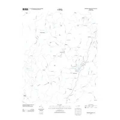
2013 Map of Herbert Domain
USGS Topo · Published 2013About this map
Hale Mill and the surrounding rural landscape of Cumberland County are defined by a network of creeks and ridges, including Buck Ridge and Sluter Ridge. The area is marked by established small communities such as Old Winesap, Midway, and Thomas Springs, connected by a web of local roads named for prominent families like Clarence Blaylock Rd and Martin Burgess Rd. This 2013 survey illustrates the balance of residential development and natural water features, from the expansive Oldfield Branch Lake to the controlled waters of Cumberland Mountain Retreat Lake Number Three. Higher elevations like Pilot Knob overlook the drainage basins of Bee Cr and Little Laurel Cr, while land use includes both the Herbert Domain and the Cumberland County Landfill. The presence of Old Rocky Ford on Bee Cr suggests long-standing transit routes across the waterways that dominate the lower half of the quadrangle.
Find a feature on this map
136 named features on this map. Tap any name to fly to it.
Don’t see what you’re looking for? This feature index may not catch every label — zoom into the map to look around manually.
Map Details
Editions of this 2013 Herbert Domain Map
This is the sole edition of this map. No revisions or reprints were ever made.
Other maps of this area

1892 · Pikeville
USGS Topo · 1:125,000

1895 · Pikeville
USGS Topo · 1:125,000

1909 · Sequatchie Valley
USGS Topo · 1:62,500

1910 · Pikeville
USGS Topo · 1:62,500

1912 · Crossville
USGS Topo · 1:62,500

1935 · Melvine
USGS Topo · 1:24,000

1935 · Billingsley Gap
USGS Topo · 1:24,000
1935 · Vandever
USGS Topo · 1:24,000
1936 · Crossville
USGS Topo · 1:24,000

1943 · Cookeville
USGS Topo · 1:100,000