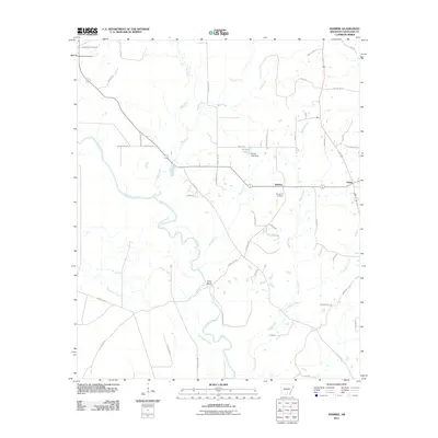
2011 Map of Herbine
USGS Topo · Published 2011About this map
The Saline River winds through this rural Cleveland County landscape, creating a network of riparian wetlands and creek systems south of Herbine. This 2011 survey highlights a region defined by its watercourses, including the confluence of Mill Branch and Bridge Creek as they feed into the main river channel near Vince Bluff. To the north and east, small settlements like Pansy are connected by a grid of named local roads such as Pansy Rd and County Rd-107, reflecting a long-established pattern of timber and agricultural land use.
Find a feature on this map
56 named features on this map. Tap any name to fly to it.
Don’t see what you’re looking for? This feature index may not catch every label — zoom into the map to look around manually.
Map Details
Editions of this 2011 Herbine Map
This is the sole edition of this map. No revisions or reprints were ever made.
Other maps of this area

1935 · Feenyville
USGS Topo · 1:62,500

1953 · Greenwood
USGS Topo · 1:250,000

1953 · El Dorado
USGS Topo · 1:250,000

1956 · Greenwood
USGS Topo · 1:250,000

1957 · El Dorado
USGS Topo · 1:250,000

1958 · El Dorado
USGS Topo · 1:250,000

1960 · El Dorado
USGS Topo · 1:250,000
1970 · Calmer
USGS Topo · 1:24,000

1970 · New Edinburg
USGS Topo · 1:24,000

1970 · Herbine
USGS Topo · 1:24,000