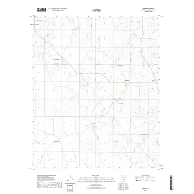
2020 Map of Herbine
USGS Topo · Published 2020About this map
Herbine and the nearby community of Pansy anchor this survey of the Cleveland County countryside, where the landscape is defined by the winding course of the Saline River. The river's floodplain is marked by prominent local landmarks like Vince Bluff and several large oxbow-style water bodies including Schultz Lake. This era shows a dense network of local roads and family-named routes such as Gwin Ln, Patrick Rd, and Shelby Ln, which connect the scattered rural homesteads to the primary settlements. Local heritage is preserved at sites like Prosperity Cem and Macedonia Cem, while the hydrology is dominated by numerous tributaries like Big Cr, Sixteenth Cr, and Little Blakey Cr. The map captures a moment of modern rural life before significant changes to the local road infrastructure or regional drainage patterns.
Find a feature on this map
53 named features on this map. Tap any name to fly to it.
Don’t see what you’re looking for? This feature index may not catch every label — zoom into the map to look around manually.
Map Details
Editions of this 2020 Herbine Map
This is the sole edition of this map. No revisions or reprints were ever made.
Other maps of this area

1935 · Feenyville
USGS Topo · 1:62,500

1953 · Greenwood
USGS Topo · 1:250,000

1953 · El Dorado
USGS Topo · 1:250,000

1956 · Greenwood
USGS Topo · 1:250,000

1957 · El Dorado
USGS Topo · 1:250,000

1958 · El Dorado
USGS Topo · 1:250,000

1960 · El Dorado
USGS Topo · 1:250,000
1970 · Calmer
USGS Topo · 1:24,000

1970 · New Edinburg
USGS Topo · 1:24,000

1970 · Herbine
USGS Topo · 1:24,000