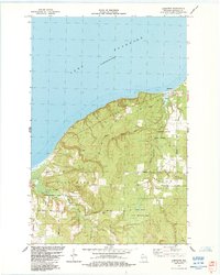
1984 Map of Herbster
USGS Topo · Published 1984About this map
Lake Superior defines the northern edge of this coastal landscape, where the settlement of Herbster serves as the focal point for a region shaped by natural resources and conservation. The interior is a complex of wetlands and timber managed through the Cranberry River State Fishery Area and Flag River State Fishery Area. These protected zones, alongside the Flag River State Wildlife Area, indicate a mid-20th-century shift toward ecological preservation as the primary land use. Local industry is represented by several Gravel Pits, while a grid of rural roads—many bearing family names like Matthews Road, Almstead Road, and Morrison Road—connects the scattered residences and farms between the township boundaries of Port Wing and Clover.
Find a feature on this map
29 named features on this map. Tap any name to fly to it.
Don’t see what you’re looking for? This feature index may not catch every label — zoom into the map to look around manually.
Map Details
Editions of this 1984 Herbster Map
This is the sole edition of this map. No revisions or reprints were ever made.
Other maps of this area

1943 · Port Wing
USGS Topo · 1:48,000

1943 · Iron Lake
USGS Topo · 1:48,000

1944 · Moquah
USGS Topo · 1:48,000

1944 · Cornucopia
USGS Topo · 1:48,000

1946 · Cornucopia
USGS Topo · 1:48,000

1946 · Port Wing
USGS Topo · 1:48,000

1947 · Moquah
USGS Topo · 1:48,000

1947 · Iron Lake
USGS Topo · 1:48,000

1953 · Ashland
USGS Topo · 1:250,000

1958 · Ashland
USGS Topo · 1:250,000