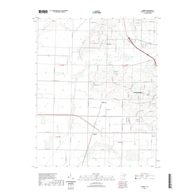
2020 Map of Herman
USGS Topo · Published 2020About this map
Crowleys Ridge rises from the landscape south of Jonesboro, providing a distinct topographic contrast to the flat alluvial plains to the west. This area of Craighead County is defined by a sophisticated drainage network including the Whaley Slough Ditch, Ark Slough Ditch, and Black Fork Ditch, which manage water across the lower-lying agricultural fields. Smaller rural settlements such as Herman, Gilkerson, and Gibson are scattered along the section lines, connected by an extensive grid of county roads. Local genealogy and history are preserved at the Bishop Cem and Gibson Cem, while the RBC Airport near Gilkerson highlights the modern infrastructure supporting this region. The map captures the edge of Jonesboro expansion, where residential developments like Big Creek Cove meet the older agricultural landscape.
Find a feature on this map
113 named features on this map. Tap any name to fly to it.
Don’t see what you’re looking for? This feature index may not catch every label — zoom into the map to look around manually.
Map Details
Editions of this 2020 Herman Map
This is the sole edition of this map. No revisions or reprints were ever made.
Other maps of this area

1935 · Sedgwick
USGS Topo · 1:62,500

1939 · Weiner
USGS Topo · 1:62,500

1939 · Jonesboro
USGS Topo · 1:62,500

1940 · Dee
USGS Topo · 1:62,500

1953 · Memphis
USGS Topo · 1:250,000

1956 · Memphis
USGS Topo · 1:250,000

1958 · Dee
USGS Topo · 1:62,500

1958 · Jonesboro
USGS Topo · 1:62,500

1959 · Weiner
USGS Topo · 1:62,500

1959 · Sedgwick
USGS Topo · 1:62,500