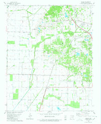
1980 Map of Herman
USGS Topo · Published 1980About this map
Crowleys Ridge dominates the eastern half of this Craighead County landscape, providing a sharp topographical contrast to the low-lying drainage basins to the west. This upland area is dotted with local landmarks including Oak Grove Ch, Bishop Cem, and West Side High Sch near the community of Herman. The lowlands are defined by an extensive network of water management, featuring several man-made channels like Black Fork Ditch, Big Creek Ditch, and Lost Creek Ditch, which redirect water around the elevated ridge.
Find a feature on this map
34 named features on this map. Tap any name to fly to it.
Don’t see what you’re looking for? This feature index may not catch every label — zoom into the map to look around manually.
Map Details
Editions of this 1980 Herman Map
This is the sole edition of this map. No revisions or reprints were ever made.
Other maps of this area

1935 · Sedgwick
USGS Topo · 1:62,500

1939 · Weiner
USGS Topo · 1:62,500

1939 · Jonesboro
USGS Topo · 1:62,500

1940 · Dee
USGS Topo · 1:62,500

1953 · Memphis
USGS Topo · 1:250,000

1956 · Memphis
USGS Topo · 1:250,000

1958 · Dee
USGS Topo · 1:62,500

1958 · Jonesboro
USGS Topo · 1:62,500

1959 · Weiner
USGS Topo · 1:62,500

1959 · Sedgwick
USGS Topo · 1:62,500