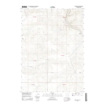
2015 Map of Herman Ranch
USGS Topo · Published 2015About this map
North Platte River winds through the northeastern corner of this Platte County landscape, carving the distinctive Wendover Canyon as it flows south. This cattle-ranching territory is anchored by the Herman Ranch, situated near the center of the survey. The terrain is defined by dry creek beds and significant elevation changes, including Pine Ridge in the west and Porter Rock to the southeast. Water sources in this arid environment are critical, highlighted by the presence of Cold Spring and the drainage systems of Cottonwood Creek and Little Cottonwood Cr. Local transportation is limited to a few primary thoroughfares, notably Cottonwood Rd and N Dwyer Rd, which provide access through the complex topography of the high plains.
Find a feature on this map
17 named features on this map. Tap any name to fly to it.
Don’t see what you’re looking for? This feature index may not catch every label — zoom into the map to look around manually.
Map Details
Editions of this 2015 Herman Ranch Map
This is the sole edition of this map. No revisions or reprints were ever made.
Other maps of this area

1896 · Hartville
USGS Topo · 1:125,000

1901 · Hartville
USGS Topo · 1:125,000

1950 · Coleman Butte
USGS Topo · 1:24,000

1950 · Herman Ranch
USGS Topo · 1:24,000

1950 · Haushar Ranch
USGS Topo · 1:24,000

1950 · Guernsey Reservoir
USGS Topo · 1:24,000

1951 · Coleman Butte
USGS Topo · 1:24,000

1951 · Sibley Peak
USGS Topo · 1:24,000

1951 · Haushar Ranch
USGS Topo · 1:24,000

1951 · Guernsey Reservoir
USGS Topo · 1:24,000