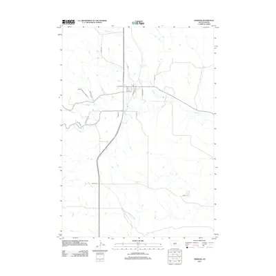
2012 Map of Hermosa
USGS Topo · Published 2012About this map
Battle Cr winds through this landscape on the eastern edge of the Black Hills, anchoring a small-town grid defined by streets like 2nd St and 5th St. The road network reflects a mix of traditional ranching access and specialized Cold War infrastructure, most notably evidenced by Missile Rd W in the southern portion of the quadrangle. Drainage patterns are dominated by several eastward-flowing seasonal streams, including Bittover Cr and Grace Coolidge Cr, which carve through the terrain near Snob Hl. Local activity centers are concentrated around Fire House Rd and Fairgrounds Pl, illustrating the community's organizational structure. The map provides a clear look at the intersection of rural land management and modern regional connectivity via Co Hwy-6 and Co Hwy-7.
Find a feature on this map
20 named features on this map. Tap any name to fly to it.
Don’t see what you’re looking for? This feature index may not catch every label — zoom into the map to look around manually.
Map Details
Editions of this 2012 Hermosa Map
This is the sole edition of this map. No revisions or reprints were ever made.
Other maps of this area

1894 · Hermosa
USGS Topo · 1:125,000

1901 · Hermosa
USGS Topo · 1:125,000

1953 · Hermosa NW
USGS Topo · 1:24,000

1953 · Hermosa
USGS Topo · 1:24,000

1953 · Hermosa SE
USGS Topo · 1:24,000
1953 · Hermosa NE
USGS Topo · 1:24,000
1954 · Rockerville
USGS Topo · 1:24,000

1954 · Hayward
USGS Topo · 1:24,000

1954 · Mount Rushmore
USGS Topo · 1:62,500

1955 · Hot Springs
USGS Topo · 1:250,000