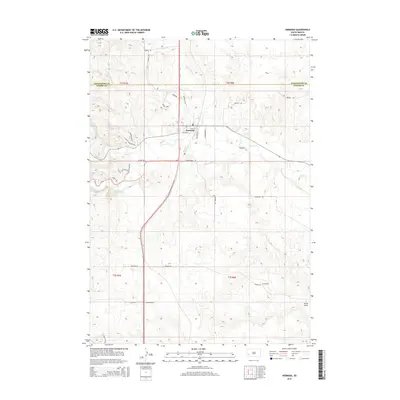
2015 Map of Hermosa
USGS Topo · Published 2015About this map
Hermosa serves as the central hub of this South Dakota landscape, situated where the high plains meet the eastern drainage of the Black Hills. The town’s grid, featuring streets like Vilas St and Whitney St, is positioned near the convergence of Battle Cr and Billover Cr. The terrain is defined by a network of drainage systems, including the notable Grace Coolidge Cr and the topographic feature known as Seven Draw in the southeast.
Find a feature on this map
33 named features on this map. Tap any name to fly to it.
Don’t see what you’re looking for? This feature index may not catch every label — zoom into the map to look around manually.
Map Details
Editions of this 2015 Hermosa Map
This is the sole edition of this map. No revisions or reprints were ever made.
Other maps of this area

1894 · Hermosa
USGS Topo · 1:125,000

1901 · Hermosa
USGS Topo · 1:125,000

1953 · Hermosa NW
USGS Topo · 1:24,000

1953 · Hermosa
USGS Topo · 1:24,000

1953 · Hermosa SE
USGS Topo · 1:24,000
1953 · Hermosa NE
USGS Topo · 1:24,000
1954 · Rockerville
USGS Topo · 1:24,000

1954 · Hayward
USGS Topo · 1:24,000

1954 · Mount Rushmore
USGS Topo · 1:62,500

1955 · Hot Springs
USGS Topo · 1:250,000