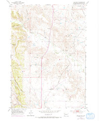
1953 Map of Hermosa NW
USGS Topo · Published 1972About this map
Spring Creek winds through this South Dakota landscape, providing a vital water source for the scattered ranching and agricultural operations of Pennington County during the mid-20th century. The settlement of Ajax and the point labeled Warbonnet represent small interior hubs of activity, while the Chicago and North Western railroad cuts a diagonal path through the southeastern corner, linking this territory to larger markets. Educational life in the rural district is anchored by the Neely Sch, situated near the creek's edge.
Find a feature on this map
20 named features on this map. Tap any name to fly to it.
Don’t see what you’re looking for? This feature index may not catch every label — zoom into the map to look around manually.
Map Details
Editions of this 1953 Hermosa NW Map
3 editions found
Other maps of this area

1893 · Rapid
USGS Topo · 1:125,000

1894 · Hermosa
USGS Topo · 1:125,000

1898 · Rapid
USGS Topo · 1:125,000

1901 · Hermosa
USGS Topo · 1:125,000

1903 · Rapid
USGS Topo · 1:125,000

1953 · Boxelder
USGS Topo · 1:24,000

1953 · Hermosa NW
USGS Topo · 1:24,000

1953 · Rapid City East
USGS Topo · 1:24,000

1953 · Hermosa
USGS Topo · 1:24,000

1953 · Rapid City West
USGS Topo · 1:24,000