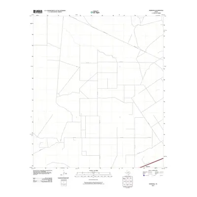
2010 Map of Hermosa
USGS Topo · Published 2010About this map
Hermosa sits at the southern edge of this West Texas landscape, where a sparse network of ranching and county roads dictates the movement across the terrain. This area of Reeves County is defined by its rectilinear property and road boundaries, notably along Shaw Rd and Co Rd 413, which suggest large-scale land divisions common in the Permian Basin region. The primary transit artery, Ranch Rd 2119, cuts diagonally across the northern portion of the quadrangle, linking the open country to distant regional hubs. The infrastructure shown by the U.S. Geological Survey reflects a landscape primarily utilized for transit and ranching, with small-scale features and local routes like Co Rd 411 and Co Rd 223 providing the only local navigational markers in a territory characterized by its wide-open orientation.
Find a feature on this map
8 named features on this map. Tap any name to fly to it.
Don’t see what you’re looking for? This feature index may not catch every label — zoom into the map to look around manually.
Map Details
Editions of this 2010 Hermosa Map
This is the sole edition of this map. No revisions or reprints were ever made.
Other maps of this area

1921 · Toyah
USGS Topo · 1:125,000

1954 · Pecos
USGS Topo · 1:250,000

1957 · Pecos
USGS Topo · 1:250,000

1961 · Sand Lake
USGS Topo · 1:24,000
1968 · Halamicek Ranch
USGS Topo · 1:24,000

1968 · Mentone SW
USGS Topo · 1:24,000

1970 · Hermosa SW
USGS Topo · 1:24,000

1970 · Big Hill
USGS Topo · 1:24,000

1970 · Toyah
USGS Topo · 1:24,000
1970 · Hermosa
USGS Topo · 1:24,000