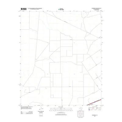
2012 Map of Hermosa
USGS Topo · Published 2012About this map
Hermosa anchors the southeast corner of this West Texas landscape, situated along a transportation corridor defined by Frontage Rd. The area is characterized by a sparse, grid-like network of rural routes and ranch roads that traverse the arid terrain of Reeves County. Surveyed by the U.S. Geological Survey, the map highlights the geometric intersection of Shaw Rd and Co Rd-413 amidst a largely undeveloped landscape. The prominence of Ranch Road 2119 cutting diagonally across the northern section illustrates the importance of these thoroughfares for connecting remote Texas ranching interests and local infrastructure in the early twenty-first century.
Find a feature on this map
10 named features on this map. Tap any name to fly to it.
Don’t see what you’re looking for? This feature index may not catch every label — zoom into the map to look around manually.
Map Details
Editions of this 2012 Hermosa Map
This is the sole edition of this map. No revisions or reprints were ever made.
Other maps of this area

1921 · Toyah
USGS Topo · 1:125,000

1954 · Pecos
USGS Topo · 1:250,000

1957 · Pecos
USGS Topo · 1:250,000

1961 · Sand Lake
USGS Topo · 1:24,000
1968 · Halamicek Ranch
USGS Topo · 1:24,000

1968 · Mentone SW
USGS Topo · 1:24,000

1970 · Hermosa SW
USGS Topo · 1:24,000

1970 · Big Hill
USGS Topo · 1:24,000

1970 · Toyah
USGS Topo · 1:24,000
1970 · Hermosa
USGS Topo · 1:24,000