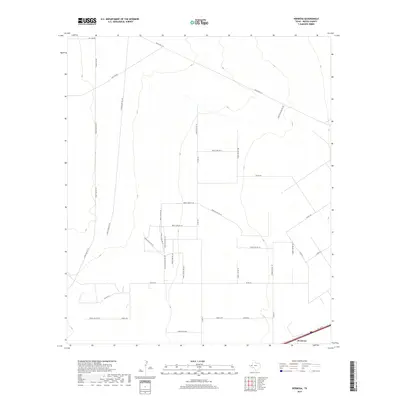
2019 Map of Hermosa
USGS Topo · Published 2019About this map
Hermosa anchors the southeast corner of this Reeves County landscape, a region defined by its expansive network of energy infrastructure and rural thoroughfares. The terrain is crisscrossed by specialized routes such as Oil Line Rd, Gas Line Rd, and Oil Field Access Rd 101, reflecting the industrial significance of the local oil and gas fields during this era. This grid of private and county roads serves a sparse but functional landscape of wells and ranches. Major transportation corridors like Ranch Rd 2119 and Farm Access Rd 129 provide the primary connections through the arid basin. Notable for researchers of West Texas industrial history, the map documents the dense web of fence lines and access roads, such as Sand Pit Access Rd 102 and Well Access Rd 103, that delineate land use and resource extraction patterns in the late 2010s.
Find a feature on this map
36 named features on this map. Tap any name to fly to it.
Don’t see what you’re looking for? This feature index may not catch every label — zoom into the map to look around manually.
Map Details
Editions of this 2019 Hermosa Map
This is the sole edition of this map. No revisions or reprints were ever made.
Other maps of this area

1921 · Toyah
USGS Topo · 1:125,000

1954 · Pecos
USGS Topo · 1:250,000

1957 · Pecos
USGS Topo · 1:250,000

1961 · Sand Lake
USGS Topo · 1:24,000
1968 · Halamicek Ranch
USGS Topo · 1:24,000

1968 · Mentone SW
USGS Topo · 1:24,000

1970 · Hermosa SW
USGS Topo · 1:24,000

1970 · Big Hill
USGS Topo · 1:24,000

1970 · Toyah
USGS Topo · 1:24,000
1970 · Hermosa
USGS Topo · 1:24,000