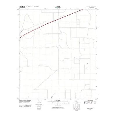
2010 Map of Hermosa SW
USGS Topo · Published 2010About this map
Salt Draw and Billingslea Draw define the drainage patterns across this arid stretch of Reeves County in West Texas. The landscape is marked by a rigorous grid of secondary and ranch roads, reflecting the large-scale land divisions and agricultural infrastructure typical of the Trans-Pecos region. Primary transit is provided by Interstate 20, which cuts diagonally across the northern portion of the map, linking the area to the broader regional economy. Significant local routes including Fm 1934, Ranch Rd 1934, and Shaw Rd provide access to the interior, while the southern reaches are drained by the notable Ninemile Draw. The presence of numerous county roads like Co RD 211 and Co RD 132 suggests a network of ranching activity and land management at the turn of the 21st century.
Find a feature on this map
18 named features on this map. Tap any name to fly to it.
Don’t see what you’re looking for? This feature index may not catch every label — zoom into the map to look around manually.
Map Details
Editions of this 2010 Hermosa SW Map
This is the sole edition of this map. No revisions or reprints were ever made.
Other maps of this area

1921 · Toyah
USGS Topo · 1:125,000

1954 · Pecos
USGS Topo · 1:250,000

1955 · Saragosa
USGS Topo · 1:62,500

1957 · Pecos
USGS Topo · 1:250,000

1970 · Hermosa SW
USGS Topo · 1:24,000

1970 · Florenzo Hill
USGS Topo · 1:24,000

1970 · Big Hill
USGS Topo · 1:24,000

1970 · Toyah
USGS Topo · 1:24,000
1970 · Hermosa
USGS Topo · 1:24,000
1970 · Saragosa NW
USGS Topo · 1:24,000