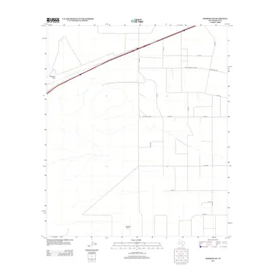
2012 Map of Hermosa SW
USGS Topo · Published 2012About this map
Billingslea Draw cuts across the northern expanse of this Reeves County landscape, a seasonal drainage characteristic of the Trans-Pecos region. The terrain is defined by a grid of rural infrastructure, where local transport depends on a network of unpaved paths like Co Rd-209 and Co Rd-211. Modern connectivity is represented by the heavy corridor of the Interstate and its accompanying Frontage Rd, which contrasts with the traditional Texas transit routes of Farm-To-Market Road 1934 and Ranch Road 1934. Near the southern boundary, Ninemile Draw provides another significant hydrological feature in this arid environment. The map illustrates a transitional period in West Texas land use, where large-scale ranching territory is increasingly bisected by regional highway development and a systematic county road grid.
Find a feature on this map
15 named features on this map. Tap any name to fly to it.
Don’t see what you’re looking for? This feature index may not catch every label — zoom into the map to look around manually.
Map Details
Editions of this 2012 Hermosa SW Map
This is the sole edition of this map. No revisions or reprints were ever made.
Other maps of this area

1921 · Toyah
USGS Topo · 1:125,000

1954 · Pecos
USGS Topo · 1:250,000

1955 · Saragosa
USGS Topo · 1:62,500

1957 · Pecos
USGS Topo · 1:250,000

1970 · Hermosa SW
USGS Topo · 1:24,000

1970 · Florenzo Hill
USGS Topo · 1:24,000

1970 · Big Hill
USGS Topo · 1:24,000

1970 · Toyah
USGS Topo · 1:24,000
1970 · Hermosa
USGS Topo · 1:24,000
1970 · Saragosa NW
USGS Topo · 1:24,000