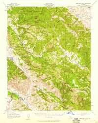
1957 Map of Hernandez Valley
USGS Topo · Published 1958About this map
Mustang Ridge and the Griswold Hills define the complex topography of this mid-century survey, where the San Benito River carves through the central valley. Small-scale ranching and early petroleum interests mark the landscape, evidenced by the De Alvarez Ranch, Laguna Ranch, and a cluster of Oil Wells and Oil Tanks near Vallecitos. The southern portion of the map is dominated by the Peachtree Valley and the Airline Highway, which follows the base of the Lorenzo Sanchez Ridge. The map documents a sparsely populated rural frontier with isolated infrastructure like the Bitterwater Tully School and an Oil Pumping Station (Inactive) near the confluence of James Creek and the river. Notable for family-named landmarks and old ranch sites, the area remains focused on cattle and early resource extraction, with many locations accessible only by Jeep Trail.
Find a feature on this map
90 named features on this map. Tap any name to fly to it.
Don’t see what you’re looking for? This feature index may not catch every label — zoom into the map to look around manually.
Map Details
Editions of this 1957 Hernandez Valley Map
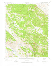
2 editions found
Other maps of this area

1913 · Panoche
USGS Topo · 1:125,000

1915 · Priest Valley
USGS Topo · 1:125,000

1919 · King City
USGS Topo · 1:62,500

1919 · San Benito
USGS Topo · 1:62,500

1921 · Metz
USGS Topo · 1:62,500

1931 · San Benito
USGS Topo · 1:62,500

1939 · King City
USGS Topo · 1:62,500

1940 · Metz
USGS Topo · 1:62,500

1940 · San Benito
USGS Topo · 1:62,500

1941 · Priest Valley
USGS Topo · 1:62,500