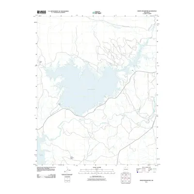
2011 Map of Heron Reservoir
USGS Topo · Published 2011About this map
Heron Reservoir dominates this landscape, its expansive waters contained by the Heron Dam above the winding Rio Chama. In this high-desert environment, the water management infrastructure is central to the area's layout, connecting with the northern edge of El Vado Reservoir at the southern boundary. To the west, El Poso Ranch stands as a notable landmark of rural land use. The topography is defined by significant drainages such as Canada de la Laguna and Willow Creek. A network of local roads like Laguna Vista Dr and Alta Vista Dr serves the residential and recreational areas adjacent to the water, while the El Vado State Park Airport provides a key transportation link for this Rio Arriba County region.
Find a feature on this map
22 named features on this map. Tap any name to fly to it.
Don’t see what you’re looking for? This feature index may not catch every label — zoom into the map to look around manually.
Map Details
Editions of this 2011 Heron Reservoir Map
This is the sole edition of this map. No revisions or reprints were ever made.
Other maps of this area

1954 · Aztec
USGS Topo · 1:250,000

1955 · Chama
USGS Topo · 1:62,500

1955 · Lumberton
USGS Topo · 1:62,500

1955 · Tierra Amarilla
USGS Topo · 1:62,500

1955 · Boulder Lake
USGS Topo · 1:62,500

1958 · Aztec
USGS Topo · 1:250,000

1962 · Aztec
USGS Topo · 1:250,000

1965 · Aztec
USGS Topo · 1:250,000

1981 · Chama
USGS Topo · 1:100,000
1983 · Pounds Mesa
USGS Topo · 1:24,000