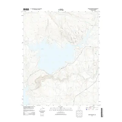
2013 Map of Heron Reservoir
USGS Topo · Published 2013About this map
Heron Reservoir dominates the high-country terrain of Rio Arriba County, where the reservoir’s indented shoreline is shaped by the surrounding mesas and canyons. The Rio Chama flows through the southern portion of the quadrangle, carving a deep path toward the northern reaches of El Vado Reservoir. This landscape is characterized by its transition from high-desert plateaus to water-carved valleys, with Cañada de la Laguna and Horse Lake Cr feeding into the larger basin. While the western shore remains largely undeveloped near El Poso Ranch, the eastern and northern heights above the water show a network of residential and access roads, including Ladera del Sol and Bueno Vista Dr. The map illustrates the convergence of NM-95 and NM-112, which serve as the primary transit arteries connecting these remote highlands to the rest of northern New Mexico.
Find a feature on this map
27 named features on this map. Tap any name to fly to it.
Don’t see what you’re looking for? This feature index may not catch every label — zoom into the map to look around manually.
Map Details
Editions of this 2013 Heron Reservoir Map
This is the sole edition of this map. No revisions or reprints were ever made.
Other maps of this area

1954 · Aztec
USGS Topo · 1:250,000

1955 · Chama
USGS Topo · 1:62,500

1955 · Lumberton
USGS Topo · 1:62,500

1955 · Tierra Amarilla
USGS Topo · 1:62,500

1955 · Boulder Lake
USGS Topo · 1:62,500

1958 · Aztec
USGS Topo · 1:250,000

1962 · Aztec
USGS Topo · 1:250,000

1965 · Aztec
USGS Topo · 1:250,000

1981 · Chama
USGS Topo · 1:100,000
1983 · Pounds Mesa
USGS Topo · 1:24,000