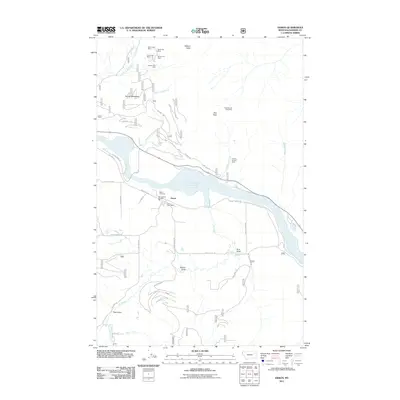
2011 Map of Heron
USGS Topo · Published 2011About this map
Heron sits along the northern banks of the Cabinet Gorge Reservoir, a major waterway that dominates the central geography of this Sanders County landscape. The settlement serves as a hub for the surrounding mountains, anchored by the Heron Post Office and the Heron Rural Fire Dist. To the north, the terrain rises sharply toward Fatman Mountain and Star Peak, where a legacy of hard-rock mining is evident in the numerous claims dotting the slopes. Notable sites include the Blue Creek Mine, Lucky Star Mine, and the Fredrick and Wind Mine. The transportation network reflects the area's industrial and rural character, with the Railroad Ave corridor following the water and various logging and access roads like Fatman Rd and Winchester Rd threading into the drainages of Dead Horse Creek and Big Eddy Creek. Downstream, the Heron Cemetery offers a point of interest for genealogists tracing the early families of this timber and mining region.
Find a feature on this map
42 named features on this map. Tap any name to fly to it.
Don’t see what you’re looking for? This feature index may not catch every label — zoom into the map to look around manually.
Map Details
Editions of this 2011 Heron Map
This is the sole edition of this map. No revisions or reprints were ever made.
Other maps of this area

1909 · Cataldo
USGS Topo · 1:125,000

1911 · Cataldo
USGS Topo · 1:125,000

1911 · Priest Lake
USGS Topo · 1:250,000

1913 · Priest Lake
USGS Topo · 1:250,000

1920 · Libby
USGS Topo · 1:125,000

1930 · Libby
USGS Topo · 1:125,000

1932 · Libby
USGS Topo · 1:125,000

1932 · Trout Creek
USGS Topo · 1:125,000

1935 · Trout Creek
USGS Topo · 1:125,000

1936 · Trout Creek
USGS Topo · 1:125,000