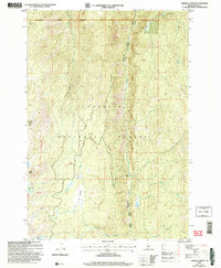
2004 Map of Hershey Point
USGS Topo · Published 2007About this map
Payette National Forest dominates this high-altitude landscape, where the New Meadows-McCall Ranger District manages a complex network of ridgelines and watercourses. The terrain is defined by the prominent Lava Butte Ridge, which serves as a backdrop for numerous mountain lakes including Lava Butte Lakes and Scribner Lake. The prominence of Hershey Point Lookout provides a central landmark for navigating this portion of the forest, which is carved by the deep drainage of French Creek and its many tributaries like Little French Creek.
Find a feature on this map
22 named features on this map. Tap any name to fly to it.
Don’t see what you’re looking for? This feature index may not catch every label — zoom into the map to look around manually.
Map Details
Editions of this 2004 Hershey Point Map
This is the sole edition of this map. No revisions or reprints were ever made.
Other maps of this area

1938 · Riggins
USGS Topo · 1:96,000

1945 · Riggins
USGS Topo · 1:125,000

1955 · Grangeville
USGS Topo · 1:250,000

1956 · Burgdorf
USGS Topo · 1:62,500

1956 · Elk City
USGS Topo · 1:250,000

1959 · Grangeville
USGS Topo · 1:250,000

1960 · Elk City
USGS Topo · 1:250,000

1963 · Black Tip
USGS Topo · 1:24,000

1963 · Hershey Point
USGS Topo · 1:24,000
1963 · Hazard Lake
USGS Topo · 1:24,000