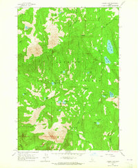
1963 Map of Hazard Lake
USGS Topo · Published 1965About this map
The Payette National Forest high country is documented here in a detailed survey by the U.S. Geological Survey. The landscape is dominated by the Grass Mountains, where dozens of alpine water bodies are concentrated in a relatively small area. The map shows the recreational and management infrastructure of the early 1960s, including a Campground near Hazard Lake and the isolated Hard Creek Guard Station. Significant landmarks like Big Hazard Lake and the Grass Mountain Lakes are connected by a network of drainages such as Hard Creek and Warm Springs Creek. The distribution of high-elevation meadows, including Hard Creek Meadow and Hard Creek Basin, indicates the area's importance for forest management and seasonal grazing. This survey provides a precise record of the backcountry before modern trail expansions or climate-driven changes altered these high mountain watersheds.
Find a feature on this map
36 named features on this map. Tap any name to fly to it.
Don’t see what you’re looking for? This feature index may not catch every label — zoom into the map to look around manually.
Map Details
Editions of this 1963 Hazard Lake Map
3 editions found
Other maps of this area

1938 · Riggins
USGS Topo · 1:96,000

1945 · Riggins
USGS Topo · 1:125,000

1955 · Grangeville
USGS Topo · 1:250,000

1959 · Grangeville
USGS Topo · 1:250,000

1963 · Bally Mountain
USGS Topo · 1:24,000

1963 · Indian Mountain
USGS Topo · 1:24,000

1963 · Granite Lake
USGS Topo · 1:24,000

1963 · Black Tip
USGS Topo · 1:24,000

1963 · Hershey Point
USGS Topo · 1:24,000
1963 · Brundage Mtn
USGS Topo · 1:24,000