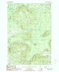
1986 Map of Hetherton
USGS Topo · Published 1986About this map
Mackinaw State Forest dominates this section of Northern Michigan, where the headwaters of the Black River and the East Branch Black River carve through a landscape of glacial lakes and wetlands. The settlement of Hetherton sits in the southwest corner, positioned near a local Gravel Pit and the edge of the Green Swamp. Historically, this area was a hub for the timber industry, a fact underscored by the numerous segments of Old Railroad Grade that crisscross the terrain, tracing the paths of long-removed logging lines.
Find a feature on this map
28 named features on this map. Tap any name to fly to it.
Don’t see what you’re looking for? This feature index may not catch every label — zoom into the map to look around manually.
Map Details
Editions of this 1986 Hetherton Map
This is the sole edition of this map. No revisions or reprints were ever made.
Other maps of this area

1949 · Lewiston
USGS Topo · 1:62,500

1950 · Lewiston
USGS Topo · 1:24,000

1950 · Johannesburg
USGS Topo · 1:24,000

1951 · Johannesburg
USGS Topo · 1:24,000

1951 · Lewiston
USGS Topo · 1:24,000

1954 · Hetherton
USGS Topo · 1:62,500

1954 · Traverse City
USGS Topo · 1:250,000

1955 · Atlanta
USGS Topo · 1:62,500

1955 · Comins
USGS Topo · 1:62,500

1955 · Cheboygan
USGS Topo · 1:250,000