
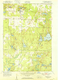
1951 Map of Johannesburg
USGS Topo · Published 1951About this map
The timber and resort landscape of Otsego County is centered on Johannesburg, where the Charlton Town Hall and Church and Full Gospel Church anchor the small community. This mid-century survey reveals a transition from a primary resource economy to a seasonal recreation hub, indicated by the presence of Echo Valley Resort on the shores of Johannesburg Lake. Much of the southern and central terrain is preserved within the Pigeon River State Forest, a geography defined by glacial kettle lakes like Big Bear Lake and the Traverse Lakes. Transportation is dominated by logging routes and local tracks such as Old State Road 618 and Beach Drive. Genealogists will find the Johannesburg Cemetery clearly marked, along with family-named landmarks like Allen Park and several private airfields, reflecting the post-war aviation boom in rural Michigan.
Find a feature on this map
40 named features on this map. Tap any name to fly to it.
Don’t see what you’re looking for? This feature index may not catch every label — zoom into the map to look around manually.
Map Details
Editions of this 1951 Johannesburg Map
2 editions found
Other maps of this area

1949 · Lewiston
USGS Topo · 1:62,500

1949 · Otsego Lake
USGS Topo · 1:62,500

1950 · Lewiston
USGS Topo · 1:24,000

1950 · Comstock Hills
USGS Topo · 1:24,000

1950 · Johannesburg
USGS Topo · 1:24,000

1950 · Lovells
USGS Topo · 1:24,000

1950 · Turtle Lake
USGS Topo · 1:24,000

1951 · K P Lake
USGS Topo · 1:24,000

1951 · Comstock Hills
USGS Topo · 1:24,000

1951 · Lovells
USGS Topo · 1:24,000