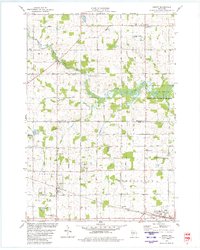
1979 Map of Hewitt
USGS Topo · Published 1980About this map
Rozellville, Hewitt, and Auburndale anchor this central Wisconsin landscape during the late 1970s, illustrating a transition between agricultural townships and protected wetlands. The Little Eau Pleine River winds through the northern half, flanked by the George W Mead State Public Hunting Grounds, while the southern reaches follow the corridor of the Soo Line Railroad.
Find a feature on this map
38 named features on this map. Tap any name to fly to it.
Don’t see what you’re looking for? This feature index may not catch every label — zoom into the map to look around manually.
Map Details
Editions of this 1979 Hewitt Map
This is the sole edition of this map. No revisions or reprints were ever made.
Other maps of this area

1902 · Marathon
USGS Topo · 1:125,000

1953 · Marathon
USGS Topo · 1:48,000

1953 · Stratford
USGS Topo · 1:48,000

1953 · Eau Claire
USGS Topo · 1:250,000

1954 · Marshfield
USGS Topo · 1:62,500

1955 · Green Bay
USGS Topo · 1:250,000

1956 · Milladore
USGS Topo · 1:48,000

1958 · Eau Claire
USGS Topo · 1:250,000

1963 · Marathon
USGS Topo · 1:62,500

1963 · Stratford
USGS Topo · 1:62,500