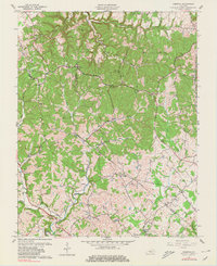
1961 Map of Hibernia
USGS Topo · Published 1980About this map
Muldraugh Hill dominates the northeast corner of this central Kentucky landscape, where the terrain breaks into the winding drainage of Otter Creek and the Middle Fork. In the early 1960s, this area on the Taylor Co Green Co line was defined by a network of small upland settlements like Hibernia and Badger, connected by winding routes like KY 210. The southern reaches of the map show an active extraction economy, with numerous Oil Wells and a Gas Well scattered across the fields near Coakley. Local life centered around a dense distribution of rural institutions, including Taylor Chapel and Mt Union Ch, alongside several family and community burial grounds such as Underwood Cem and Poplar Grove Cem. The intricate pattern of field lines and timbered hollows illustrates a long-standing agricultural tradition transitioning into the mid-century era.
Find a feature on this map
37 named features on this map. Tap any name to fly to it.
Don’t see what you’re looking for? This feature index may not catch every label — zoom into the map to look around manually.
Map Details
Editions of this 1961 Hibernia Map
2 editions found
Other maps of this area

1953 · Howardstown
USGS Topo · 1:24,000

1953 · Saloma
USGS Topo · 1:24,000

1953 · Hudgins
USGS Topo · 1:24,000

1953 · Hibernia
USGS Topo · 1:24,000

1953 · Summersville
USGS Topo · 1:24,000

1953 · Magnolia
USGS Topo · 1:24,000
1953 · Hodgenville
USGS Topo · 1:24,000

1953 · Raywick
USGS Topo · 1:24,000

1954 · Greensburg
USGS Topo · 1:24,000

1957 · Winchester
USGS Topo · 1:250,000