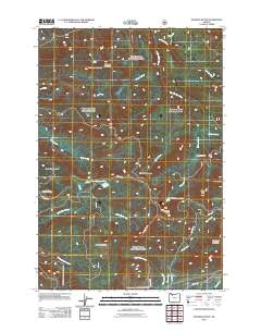
2011 Map of Hickman Butte
USGS Topo · Published 2011About this map
The Bull Run Watershed dominates the northern reaches of this territory, where a dense network of watercourses including Blazed Alder Creek and Fir Creek feed the Bull Run River. This highland landscape is defined by its dramatic relief, anchored by prominent peaks such as Hickman Butte, Thimble Mountain, and Big Bend Mountain. The terrain transitions from these high ridges down toward the southern drainage of the Little Sandy River and the Sandy River at the far southeastern corner.
Find a feature on this map
32 named features on this map. Tap any name to fly to it.
Don’t see what you’re looking for? This feature index may not catch every label — zoom into the map to look around manually.
Map Details
Editions of this 2011 Hickman Butte Map
This is the sole edition of this map. No revisions or reprints were ever made.
Other maps of this area

1916 · Estacada
USGS Topo · 1:125,000

1924 · Mount Hood
USGS Topo · 1:125,000

1926 · Hood River
USGS Topo · 1:125,000

1927 · Mount Hood
USGS Topo · 1:125,000

1929 · Hood River
USGS Topo · 1:125,000

1948 · Vancouver
USGS Topo · 1:250,000

1950 · Vancouver
USGS Topo · 1:250,000

1950 · Vancouver
USGS Topo · 1:250,000

1953 · The Dalles
USGS Topo · 1:250,000

1954 · Bridal Veil
USGS Topo · 1:62,500