
1960 Map of Hickok SE
USGS Topo · Published 1961About this map
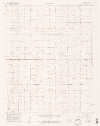
The boundary between Grant Co and Haskell Co divides this 1960 landscape, where the expansion of the Hugoton natural gas field is the primary driver of human activity. The survey reveals a grid of development defined by countless Gas Wells that punctuate the terrain alongside a network of section roads. While industrial in character, the map preserves older layers of the social geography, specifically the four named townships: Sherman, Eubank, Dudley, and Sullivan. Genealogical interest is anchored by the presence of the Canaan Cem, providing a fixed point of local history amidst the shifting energy infrastructure. A solitary Radio Tower stands as a prominent landmark in the southern half of the quadrangle, reflecting mid-century communication needs in this part of western Kansas.
Find a feature on this map
8 named features on this map. Tap any name to fly to it.
Don’t see what you’re looking for? This feature index may not catch every label — zoom into the map to look around manually.
Map Details
Editions of this 1960 Hickok SE Map
2 editions found
Other maps of this area

1891 · Larned
USGS Topo · 1:125,000

1896 · Garden
USGS Topo · 1:125,000

1900 · Lakin
USGS Topo · 1:125,000

1944 · Moscow
USGS Topo · 1:62,500

1945 · Moscow
USGS Topo · 1:62,500

1955 · Dodge City
USGS Topo · 1:250,000

1958 · Dodge City
USGS Topo · 1:250,000

1959 · Dodge City
USGS Topo · 1:250,000

1959 · Hickok NW
USGS Topo · 1:24,000

1959 · Hickok
USGS Topo · 1:24,000