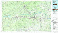
1986 Map of Hickory
USGS Topo · Published 1986About this map
The Catawba River serves as the central artery for this mid-1980s landscape, connecting a string of industrial and residential centers from Morganton and Lenoir through Hickory and Newton. This era shows a region defined by its water-powered history and educational growth, evidenced by the presence of Lenoir-Rhyne College and the Caldwell Community College and Technical Institute. The transition from the high elevations of the Blue Ridge and Linville Gorge in the west to the rolling Piedmont is marked by a series of hydroelectric reservoirs, including Rhodhiss Lake, Hickory Lake, and Norman Lake. Between these busy corridors, rural pockets like Advent Crossroads and Providence Mill maintain a traditional character. The map also reveals the extensive boundaries of the Pisgah National Forest and South Mountains State Park, highlighting the balance between urban development and the preservation of the mountain wilderness.
Find a feature on this map
140 named features on this map. Tap any name to fly to it.
Don’t see what you’re looking for? This feature index may not catch every label — zoom into the map to look around manually.
Map Details
Editions of this 1986 Hickory Map
3 editions found
Other maps of this area

1889 · Wilkesboro
USGS Topo · 1:125,000

1891 · Roan Mountain
USGS Topo · 1:125,000

1891 · Wilkesboro
USGS Topo · 1:125,000

1891 · Yadkinville
USGS Topo · 1:125,000

1893 · Cranberry
USGS Topo · 1:125,000

1893 · Statesville
USGS Topo · 1:125,000

1893 · Yadkinville
USGS Topo · 1:125,000

1894 · Roan Mountain
USGS Topo · 1:125,000

1895 · Hickory
USGS Topo · 1:125,000

1895 · Cranberry
USGS Topo · 1:125,000