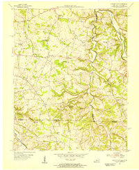
1954 Map of Hickory Flat
USGS Topo · Published 1956About this map
Hickory Flat and Highland anchor this mid-century look at the borderland between Kentucky and Tennessee. The landscape is defined by the winding course of the Middle Fork Drakes Creek and Sulphur Fork, where numerous small tributaries like Mays Branch and Smyrna Branch carve out a complex network of ridges and hollows. This topography heavily influenced the placement of rural institutions, with dozens of country churches and schools serving local farming families across the Simpson and Allen County line.
Find a feature on this map
39 named features on this map. Tap any name to fly to it.
Don’t see what you’re looking for? This feature index may not catch every label — zoom into the map to look around manually.
Map Details
Editions of this 1954 Hickory Flat Map
This is the sole edition of this map. No revisions or reprints were ever made.
Other maps of this area

1921 · Bowling Green
USGS Topo · 1:62,500

1923 · Bowling Green
USGS Topo · 1:62,500

1928 · Adolphus
USGS Topo · 1:48,000

1931 · Adolphus
USGS Topo · 1:62,500

1942 · Gallatin
USGS Topo · 1:100,000

1951 · Woodburn
USGS Topo · 1:24,000

1951 · Franklin
USGS Topo · 1:24,000

1954 · Drake
USGS Topo · 1:24,000

1954 · Adolphus
USGS Topo · 1:24,000
1954 · Allen Springs
USGS Topo · 1:24,000