
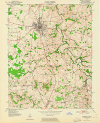
1951 Map of Franklin
USGS Topo · Published 1952About this map
Franklin serves as the central hub of this early 1950s survey, where the Louisville and Nashville railroad bisects the town and dictates the local transit patterns. The landscape is defined by the winding course of the West Fork Drakes Creek, which supported early industrial activity such as the Peden Mill. Small agricultural communities and family-named landmarks are scattered throughout the countryside, connected by a network of rural roads crossing the state line into Tennessee. Genealogists will find significant detail in the rural corners of the map, from the Lake Spring Sch to various family burial grounds including the Peden Cem and Chisholm Cem. In the southern reaches, the settlements of Mitchellville and Black Jack sit near the boundary of Robertson and Sumner counties, illustrating the cross-border commerce of the mid-century era.
Find a feature on this map
34 named features on this map. Tap any name to fly to it.
Don’t see what you’re looking for? This feature index may not catch every label — zoom into the map to look around manually.
Map Details
Editions of this 1951 Franklin Map
2 editions found
Other maps of this area

1921 · Bowling Green
USGS Topo · 1:62,500

1923 · Bowling Green
USGS Topo · 1:62,500

1928 · Adolphus
USGS Topo · 1:48,000

1931 · Adolphus
USGS Topo · 1:62,500

1942 · Gallatin
USGS Topo · 1:100,000

1951 · Woodburn
USGS Topo · 1:24,000

1951 · Prices Mill
USGS Topo · 1:24,000

1951 · Auburn
USGS Topo · 1:24,000

1953 · Orlinda
USGS Topo · 1:24,000

1954 · Drake
USGS Topo · 1:24,000