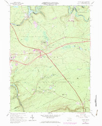
1966 Map of Hickory Run
USGS Topo · Published 1984About this map
The Lehigh River carves a deep path through the Pocono Mountains on this survey, serving as the border between Luzerne and Carbon counties. The completion of the Francis E Walter Dam near Bear Creek transformed the local topography, while the Northeast Extension Pennsylvania Turnpike cut a modern corridor through the terrain, introducing major interchanges such as Interchange 35.
Find a feature on this map
51 named features on this map. Tap any name to fly to it.
Don’t see what you’re looking for? This feature index may not catch every label — zoom into the map to look around manually.
Map Details
Editions of this 1966 Hickory Run Map
Other maps of this area

1889 · Hazleton
USGS Topo · 1:62,500

1891 · Wilkesbarre
USGS Topo · 1:62,500

1891 · Hazleton
USGS Topo · 1:62,500

1893 · Hazleton
USGS Topo · 1:62,500

1894 · Wilkesbarre
USGS Topo · 1:62,500

1922 · Mauch Chunk
USGS Topo · 1:62,500

1922 · Stoddartsville
USGS Topo · 1:62,500

1924 · Stoddartsville
USGS Topo · 1:62,500

1924 · Mauch Chunk
USGS Topo · 1:62,500

1943 · Scranton
USGS Topo · 1:125,000
Featured Places
- Kidder Township, PA
- Buck Township, PA
- Penn Forest Township, PA
- Tobyhanna Township, PA
- Saylorsville, Kidder Township