1922 Map of Stoddartsville
USGS Topo · Published 1968About this map
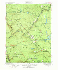
Stoddartsville sits at the heart of this survey, where the Lehigh River defines the complex boundary between Luzerne and Monroe Counties. The landscape reflects an era of early industrial and transit development, featuring the Ice Company works along Bear Creek and the transit corridor of the Wilkes-Barre and Eastern. Several local education hubs serve the scattered settlements, including the Blakeslee School, Fayette School, and Fishery School. Much of the eastern territory is dominated by the Tobyhanna Military Reservation and a sprawling State Game Preserve. The map documents a transition in transportation as the Northeast Turnpike Extension cuts through the region, intersecting with established local routes like White Haven Road. Smaller hamlets like Irishtown, Bradys Switch, and Albrightsville provide important markers for genealogists tracing family roots in this corner of the Poconos.
Find a feature on this map
105 named features on this map. Tap any name to fly to it.
Don’t see what you’re looking for? This feature index may not catch every label — zoom into the map to look around manually.
Map Details
Editions of this 1922 Stoddartsville Map
2 editions found

Other maps of this area

1889 · Scranton
USGS Topo · 1:62,500

1889 · Hazleton
USGS Topo · 1:62,500

1891 · Wilkesbarre
USGS Topo · 1:62,500

1891 · Hazleton
USGS Topo · 1:62,500

1891 · Scranton
USGS Topo · 1:62,500

1893 · Hazleton
USGS Topo · 1:62,500

1893 · Pittston
USGS Topo · 1:62,500

1893 · Scranton
USGS Topo · 1:62,500

1894 · Wilkesbarre
USGS Topo · 1:62,500

1914 · Wind Gap
USGS Topo · 1:62,500
Featured Places
- Clifton Township, PA
- Thornhurst Township, PA
- Kidder Township, PA
- Buck Township, PA
- Pocono Pines, Tobyhanna Township