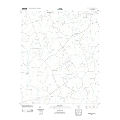
2011 Map of Hickory Tavern
USGS Topo · Published 2011About this map
Hickory Tavern serves as the central hub of this Laurens County landscape, where rural roads converge amidst a network of active watercourses. The drainage patterns of South Rabon Creek and North Rabon Creek dominate the interior, while the Reedy River defines the western edge of the quadrangle. This 2011 survey reveals a deeply rooted community characterized by numerous family and church burial grounds, including the Babb Cemetery, Dials Cemetery, and Henderson Cemetery. The presence of Babb Pond Dam D-3018 and Riddle Pond Dam D-2909 indicates water management for local agriculture or residential use. To the north, the settlement of Green Pond and its associated Green Pond Cemetery further illustrate the established settlement patterns of the South Carolina upstate, where small communities developed along creek branches and crossroads like Old Hwy 76.
Find a feature on this map
127 named features on this map. Tap any name to fly to it.
Don’t see what you’re looking for? This feature index may not catch every label — zoom into the map to look around manually.
Map Details
Editions of this 2011 Hickory Tavern Map
This is the sole edition of this map. No revisions or reprints were ever made.
Other maps of this area

1892 · Abbeville
USGS Topo · 1:125,000

1954 · Greenville
USGS Topo · 1:250,000

1957 · Fountain Inn
USGS Topo · 1:62,500

1957 · Williamston
USGS Topo · 1:62,500

1958 · Greenville
USGS Topo · 1:250,000
1971 · Ware Shoals East
USGS Topo · 1:24,000
1971 · Laurens South
USGS Topo · 1:24,000
1971 · Ware Shoals West
USGS Topo · 1:24,000
1979 · Abbeville
USGS Topo · 1:100,000
1983 · Fork Shoals
USGS Topo · 1:24,000