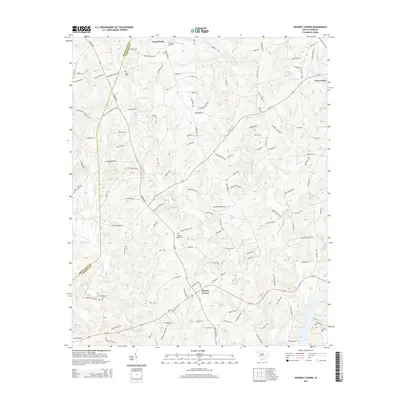
2014 Map of Hickory Tavern
USGS Topo · Published 2014About this map
Hickory Tavern and the rural hills of Laurens County are defined by a network of creeks and family-named cemeteries in this 2014 topographic study. The landscape is deeply carved by the S Rabon Cr and N Rabon Cr, which feed into larger systems like the Reedy River and Lick Cr. A significant concentration of burial sites, including Green Pond Cem, Babb Cem, and Henderson Cem, speaks to the long-established communities that centered around local congregations such as Rabun Church and New Prospect Church. These landmarks, along with established settlements like Green Pond and the periphery of Gray Court, are connected by historic routes like SC-101 and the Old US 76. The map documents the persistent rural character of the region, where topographical features like Tumbling Shoals and Horse Cr remain prominent alongside modern residential developments.
Find a feature on this map
135 named features on this map. Tap any name to fly to it.
Don’t see what you’re looking for? This feature index may not catch every label — zoom into the map to look around manually.
Map Details
Editions of this 2014 Hickory Tavern Map
This is the sole edition of this map. No revisions or reprints were ever made.
Other maps of this area

1892 · Abbeville
USGS Topo · 1:125,000

1954 · Greenville
USGS Topo · 1:250,000

1957 · Fountain Inn
USGS Topo · 1:62,500

1957 · Williamston
USGS Topo · 1:62,500

1958 · Greenville
USGS Topo · 1:250,000
1971 · Ware Shoals East
USGS Topo · 1:24,000
1971 · Laurens South
USGS Topo · 1:24,000
1971 · Ware Shoals West
USGS Topo · 1:24,000
1979 · Abbeville
USGS Topo · 1:100,000
1983 · Fork Shoals
USGS Topo · 1:24,000