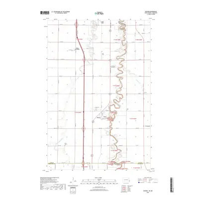
2018 Map of Hickson
USGS Topo · Published 2018About this map
The Red River of the North defines the border between North Dakota and Minnesota, its tightly wound meanders dominating the landscape south of Fargo. Along the western banks, the Wild Rice River converges with the Red near the settlement of Wild Rice. This region is characterized by a dense network of sectional roads and small communities like Hickson and the riverside enclave of Oxbow. Genealogists will find a high concentration of burial grounds, including the North Pleasant Cem and the Saint Benedict Cem near the town of Saint Benedict. The map also captures the eastern boundary of the Red River valley with the inclusion of Wolverton Cr and the town of Comstock across the state line in Minnesota, illustrating the shared agrarian geography of Cass and Clay Counties.
Find a feature on this map
69 named features on this map. Tap any name to fly to it.
Don’t see what you’re looking for? This feature index may not catch every label — zoom into the map to look around manually.
Map Details
Editions of this 2018 Hickson Map
This is the sole edition of this map. No revisions or reprints were ever made.
Other maps of this area

1895 · Fargo
USGS Topo · 1:125,000

1897 · Fargo
USGS Topo · 1:125,000

1953 · Fargo
USGS Topo · 1:250,000

1956 · Fargo
USGS Topo · 1:250,000

1959 · South West Fargo
USGS Topo · 1:24,000

1959 · Fargo South
USGS Topo · 1:24,000

1959 · Hickson
USGS Topo · 1:24,000
1959 · Walcott
USGS Topo · 1:24,000

1959 · Christine
USGS Topo · 1:24,000
1959 · Norman
USGS Topo · 1:24,000