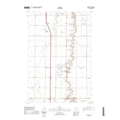
2020 Map of Hickson
USGS Topo · Published 2020About this map
The Red River of the North winds in sharp, serpentine loops through this Red River Valley landscape, forming the natural border between North Dakota and Minnesota. This region, south of Fargo, is defined by its deep agricultural roots and a cluster of small communities established along the river and the North-South highway corridors. The settlement of Saint Benedict stands in the west near the Wild Rice River, anchored by the Saint Benedict Cem. To the east, the meandering riverfront is dotted with local landmarks and burial grounds, including the Lower Wild Rice and Red River Cem and Hoff Cem. Further south, the community of Oxbow sits within a prominent river bend adjacent to Hickson. The landscape is a study in precision-gridded section lines, where county roads like Co RD 14 and Co HWY 2 connect these quiet rural centers.
Find a feature on this map
59 named features on this map. Tap any name to fly to it.
Don’t see what you’re looking for? This feature index may not catch every label — zoom into the map to look around manually.
Map Details
Editions of this 2020 Hickson Map
This is the sole edition of this map. No revisions or reprints were ever made.
Other maps of this area

1895 · Fargo
USGS Topo · 1:125,000

1897 · Fargo
USGS Topo · 1:125,000

1953 · Fargo
USGS Topo · 1:250,000

1956 · Fargo
USGS Topo · 1:250,000

1959 · South West Fargo
USGS Topo · 1:24,000

1959 · Fargo South
USGS Topo · 1:24,000

1959 · Hickson
USGS Topo · 1:24,000
1959 · Walcott
USGS Topo · 1:24,000

1959 · Christine
USGS Topo · 1:24,000
1959 · Norman
USGS Topo · 1:24,000