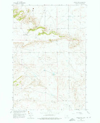
1956 Map of Hickson Ranch
USGS Topo · Published 1976About this map
Hickson Ranch serves as a primary namesake and anchor for this mid-century topographic record of Yellowstone County. The landscape is defined by the drainage of Burnt Coulee and the distinct elevation of Rattlesnake Butte on the eastern edge. This mapping, produced by the Geological Survey for the Missouri River Basin development program, illustrates a sparsely populated ranching environment where infrastructure was limited to essential connections like Alexander Road.
Find a feature on this map
6 named features on this map. Tap any name to fly to it.
Don’t see what you’re looking for? This feature index may not catch every label — zoom into the map to look around manually.
Map Details
Editions of this 1956 Hickson Ranch Map
2 editions found
Other maps of this area

1893 · Huntley
USGS Topo · 1:125,000

1954 · Billings
USGS Topo · 1:250,000

1954 · Roundup
USGS Topo · 1:250,000

1956 · Rattlesnake Butte
USGS Topo · 1:24,000

1956 · Acton
USGS Topo · 1:24,000

1956 · Hickson Ranch
USGS Topo · 1:24,000

1956 · Rimrock
USGS Topo · 1:24,000

1956 · Billings East
USGS Topo · 1:24,000

1957 · Billings
USGS Topo · 1:250,000

1957 · Billings West
USGS Topo · 1:24,000