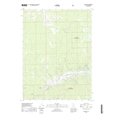
2020 Map of Hidden Lake
USGS Topo · Published 2020About this map
Wasatch National Forest dominates this mountain landscape, where the headwaters of the Weber River and the S Fork Chalk Cr carve through high-elevation terrain. Local landmarks such as the Mahogany Hills and Whites Basin define the western reaches of the sheet, while the central portion is marked by the secluded waters of Hidden Lake. The map reveals a complex network of forest roads and trails, including the Buffalo Loop and Jim Bridger Rd, which facilitate movement across the ridgelines. Near the southeastern corner, the landscape rises toward Sunrise Ridge and Moose Hollow, punctuated by high-country water bodies like Shingle Mill Lake. This data captures a moment in the modern management of these public lands, showing how contemporary access routes intersect with named drainages such as Smith and Morehouse Cr and Nobletts Creek.
Find a feature on this map
58 named features on this map. Tap any name to fly to it.
Don’t see what you’re looking for? This feature index may not catch every label — zoom into the map to look around manually.
Map Details
Editions of this 2020 Hidden Lake Map
This is the sole edition of this map. No revisions or reprints were ever made.
Other maps of this area

1885 · Salt Lake
USGS Topo · 1:250,000

1900 · Coalville
USGS Topo · 1:125,000

1903 · Coalville
USGS Topo · 1:125,000

1954 · Salt Lake City
USGS Topo · 1:250,000

1958 · Salt Lake City
USGS Topo · 1:250,000

1960 · Salt Lake City
USGS Topo · 1:250,000
1967 · Turner Hollow
USGS Topo · 1:24,000

1967 · Kamas
USGS Topo · 1:24,000
1967 · Upton
USGS Topo · 1:24,000
1967 · Crandall Canyon
USGS Topo · 1:24,000