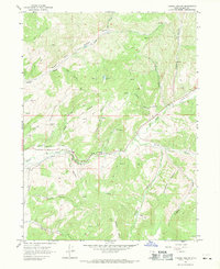
1967 Map of Turner Hollow
USGS Topo · Published 1969About this map
Grass Creek (Site) sits at the northern end of this mid-century survey, marking a former settlement area within the Grass Creek Valley. The landscape is defined by the industrial extraction and water management of Summit County, featuring the Weber Mine and Chappell Mine situated near the canyon walls. Water diversion is central to the area's geography, shown through the North Narrows Ditch and Robinson Ditch which parallel Chalk Creek as it winds through The Narrows.
Find a feature on this map
33 named features on this map. Tap any name to fly to it.
Don’t see what you’re looking for? This feature index may not catch every label — zoom into the map to look around manually.
Map Details
Editions of this 1967 Turner Hollow Map
This is the sole edition of this map. No revisions or reprints were ever made.
Other maps of this area

1885 · Salt Lake
USGS Topo · 1:250,000

1900 · Coalville
USGS Topo · 1:125,000

1903 · Coalville
USGS Topo · 1:125,000

1954 · Salt Lake City
USGS Topo · 1:250,000

1954 · Ogden
USGS Topo · 1:250,000

1958 · Ogden
USGS Topo · 1:250,000

1958 · Salt Lake City
USGS Topo · 1:250,000

1960 · Ogden
USGS Topo · 1:250,000

1960 · Salt Lake City
USGS Topo · 1:250,000
1964 · Henefer
USGS Topo · 1:24,000