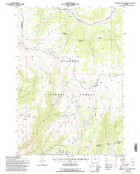
1993 Map of Hidden Tepee Creek
USGS Topo · Published 1997About this map
The Medicine Wheel Passage Scenic Byway winds through the northern reaches of the Bighorn National Forest, tracing a high-elevation route across the divide between Big Horn and Sheridan Counties. This high-country landscape is defined by its network of water resources and seasonal grazing infrastructure, including numerous stock tanks and the Horse Creek Cow Camp. The map documents a complex system of livestock and recreational paths, from the Medicine Wheel Trail to the Sunlight Cutoff Trail, which navigate the steep descent from Wallrock down toward the North Tongue River. The distribution of corrals and named water sources like Wheddon Spring and Wolf Springs illustrates the enduring importance of mountain pasturage in this corner of the Bighorn range during the late twentieth century.
Find a feature on this map
39 named features on this map. Tap any name to fly to it.
Don’t see what you’re looking for? This feature index may not catch every label — zoom into the map to look around manually.
Map Details
Editions of this 1993 Hidden Tepee Creek Map
This is the sole edition of this map. No revisions or reprints were ever made.
Other maps of this area

1898 · Bald Mountain
USGS Topo · 1:125,000

1901 · Bald Mountain
USGS Topo · 1:125,000

1955 · Sheridan
USGS Topo · 1:250,000

1958 · Sheridan
USGS Topo · 1:250,000

1960 · Shell Falls
USGS Topo · 1:24,000

1960 · Black Mountain
USGS Topo · 1:24,000

1960 · Granite Pass
USGS Topo · 1:24,000

1960 · Hidden Tepee Creek
USGS Topo · 1:24,000

1960 · Shell
USGS Topo · 1:24,000
1960 · Bald Mountain
USGS Topo · 1:24,000