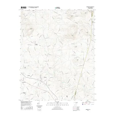
2016 Map of Hiddenite
USGS Topo · Published 2016About this map
Hiddenite and the surrounding foothill country of the South Yadkin River valley are shown in this contemporary landscape. The map illustrates a region where rural roads like Millsaps Farm Ln and Vashti Cemetery Rd connect longstanding communities. Notable topographic landmarks rise throughout the area, including the distinctive Rocky Face, Asbury Mtn, and Lackey Mtn. The settlement pattern centers on several established towns and clusters such as Taylorsville, Stony Point, and Love Valley, which is situated near the Alexander Co Iredell Co line. Transportation infrastructure is represented by a network of local roads and the Gryder-Teague Airport. This modern survey records the continued development of established rural centers alongside water features like Wallace Cr and Snow Creek, documenting how the local geography continues to shape the community layout.
Find a feature on this map
143 named features on this map. Tap any name to fly to it.
Don’t see what you’re looking for? This feature index may not catch every label — zoom into the map to look around manually.
Map Details
Editions of this 2016 Hiddenite Map
This is the sole edition of this map. No revisions or reprints were ever made.
Other maps of this area

1889 · Wilkesboro
USGS Topo · 1:125,000

1891 · Wilkesboro
USGS Topo · 1:125,000

1891 · Yadkinville
USGS Topo · 1:125,000

1893 · Statesville
USGS Topo · 1:125,000

1893 · Yadkinville
USGS Topo · 1:125,000

1895 · Hickory
USGS Topo · 1:125,000

1953 · Charlotte
USGS Topo · 1:250,000

1953 · Winston-Salem
USGS Topo · 1:250,000

1954 · Charlotte
USGS Topo · 1:250,000

1955 · Winston-Salem
USGS Topo · 1:250,000