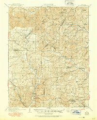
1910 Map of Higdon
USGS Topo · Published 1950About this map
Nations Mill and other local industry landmarks anchor this early 20th-century view of the Missouri Ozarks borderlands, where the drainage of the Castor River and Whitewater River shaped early settlement. This map reflects a landscape organized by rural school districts and parish life, featuring numerous educational sites like Bandendistle School and Walnut Grove School. The presence of several grist mills, including Hahns Mill and Heitmans Mill, points to an economy still driven by water power and local agriculture before the widespread expansion of heavy infrastructure. Small villages like Higdon and Womack serve as central nodes for the surrounding farms and homesteads. Historic transportation routes such as the Mine Lamotte Ferry Road provide insight into the regional connectivity of the era, linking remote townships across the county boundaries of Perry, Madison, and Bollinger.
Find a feature on this map
79 named features on this map. Tap any name to fly to it.
Don’t see what you’re looking for? This feature index may not catch every label — zoom into the map to look around manually.
Map Details
Editions of this 1910 Higdon Map
2 editions found
Other maps of this area

1904 · Farmington
USGS Topo · 1:62,500

1906 · Farmington
USGS Topo · 1:62,500

1907 · Weingarten
USGS Topo · 1:62,500

1909 · Weingarten
USGS Topo · 1:62,500

1910 · Higdon
USGS Topo · 1:62,500

1915 · Chester
USGS Topo · 1:62,500

1923 · Perryville
USGS Topo · 1:62,500

1924 · Perryville
USGS Topo · 1:62,500

1930 · Coldwater
USGS Topo · 1:62,500

1933 · Marble Hill
USGS Topo · 1:62,500