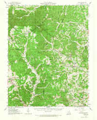
1959 Map of Higdon
USGS Topo · Published 1967About this map
The rugged hill country of the Clark National Forest dominates this mid-century landscape, where isolated settlements and family-named landmarks are connected by a network of winding creek beds and narrow hollows. Settled pockets like Womack, Higdon, and Patton serve as focal points for rural life, supported by a dense distribution of local institutions including Mt Gilead Ch and Hahns Mill. The terrain is defined by the drainage of the Castor River and the Whitewater River, with numerous small cemeteries such as McDowell Cem and Underwood Cem scattered across the ridges.
Find a feature on this map
76 named features on this map. Tap any name to fly to it.
Don’t see what you’re looking for? This feature index may not catch every label — zoom into the map to look around manually.
Map Details
Editions of this 1959 Higdon Map
2 editions found
Other maps of this area

1904 · Farmington
USGS Topo · 1:62,500

1906 · Farmington
USGS Topo · 1:62,500

1907 · Weingarten
USGS Topo · 1:62,500

1909 · Weingarten
USGS Topo · 1:62,500

1910 · Higdon
USGS Topo · 1:62,500

1915 · Chester
USGS Topo · 1:62,500

1923 · Perryville
USGS Topo · 1:62,500

1924 · Perryville
USGS Topo · 1:62,500

1930 · Coldwater
USGS Topo · 1:62,500

1933 · Marble Hill
USGS Topo · 1:62,500